Henley Town Map
Please use the map below to navigate around Henley-on-Thames.
Note: This area of the site is experimental and may therefore exhibit unpredictable behaviour. Please send us your feedback so that we can improve.
Note: If you are looking for a downloadable/printable map of Henley you may find this Henley map on the Henley Town Council website more useful.
Assendon
Assendon is a small village located just north of Henley. It is part of the Bix and Assendon parish.
[see photos]
Aston
Aston is a small village located on the outskirts of Henley very close to the River Thames. The local pub is called The Flower Pot.
[see photos]
Baronsmead
Baronsmead is a small residential cul-de-sac that branches off Kings Road in Henley.
[see photos]
Bell Street
Bell Street is the main high street in Henley. It is where most of the major national high street retailers can be found.
[see photos]
Berkshire Road
Berkshire Road is a residential road in Henley. It is one of a group of roads that run parallel to each other joining St Andrews Road to Peppard Lane.
[see photos]
Blandy Road
Blandy Road is a residential road situated on the edge of Henley. It runs parallel to the playing fields of Gillott's School.
[see photos]
Duke Street
Duke Street is the second most prominent street in Henley with numerous shops of varying types.
[see photos]
Fair Mile
Fair Mile is one of the major entrance roads to Henley. Its appearance provides a most striking first impression for visitors to the town.
[see photos]
Friar Park
Friar Park is a large private estate with a gothic mansion located in Henley. It was built by Sir Frank Crisp and was the home of the Beatle George Harrison.
[see photos]
Friday Street
Friday Street runs down towards the river and is home to residential properties, a few shops and a chippy.
[see photos]
Gillotts Close
Gillotts Close is a very small residential road situated on the outskirts of Henley. As its name implies it is fairly close to Gillotts School.
[see photos]
Gravel Hill
Gravel Hill is a fairly long road that runs from the town centre out of Henley-on-Thames.
[see photos]
Gravett Close
Gravett Close is a small residential road situated towards to edge of Henley-on-Thames.
[see photos]
Greys Road
Greys Road is a long road that provides access to Henley from the nearby village of Greys. Greys Road car park is situated at the bottom of the hill in the town centre.
[see photos]
Hambleden
Hambleden is an extremely beautiful village located a few miles away from Henley-on-Thames.
[see photos]
Harpsden Road
Harpsden Road is situated on the far side of the town and runs parallel to Reading Road.
[see photos]
Hart Street
Hart Street is one of the four major roads situated in the centre of Henley. It dates back to around the 16th century.
[see photos]
Henley Bridge
Henley Bridge is a five arched bridge which was built in 1786 that crosses the River Thames from Remenham to Henley.
[see photos]
Hop Gardens
Hop Gardens is a residential road that runs alongside Friar Park in Henley-on-Thames.
[see photos]
King James Way
King James Way is a small residential road situated on the outskirts of Henley-on-Thames.
[see photos]
Kings Road
Kings Road is a residential road that runs parallel to Bell Street in Henley-on-Thames.
[see photos]
Lambridge Wood Road
Lambridge Wood Road is a quiet residential area on the outskirts of Henley-on-Thames.
[see photos]
Lovell Close
Lovell Close is a small residential area located on the edge of Henley-on-Thames.
[see photos]
Makins Road
Makins Road is a small residential road situated on the edge of Henley-on-Thames.
[see photos]
Manor Road
Manor Road is a residential road situated on the edge of Henley-on-Thames.
[see photos]
Market Place
Market Place is a semi-pedestrianised area located in the centre of Henley directly in front of the Town Hall.
[see photos]
Marlow Road
Marlow Road is a major entry road to the town of Henley-on-Thames.
[see photos]
Mill Lane
Mill Lane is a fairly long lane that runs from Reading Road to The River Thames next to the weir. Mill Lane crosses the main Henley-on-Thames railway track.
[see photos]
Mount View
Mount View is a short residential road situated on the edge of the town centre in Henley-on-Thames.
[see photos]
New Street
New Street runs down to the river in Henley-on-Thames. New Street is home to The Kenton Theatre.
[see photos]
Newtown
Newtown is a major business area in Henley-on-Thames.
[see photos]
Niagara Road
Niagara Road is a residential road located in Henley-on-Thames.
[see photos]
Northfield End
Northfield End is a busy traffic area on the edge of Henley-on-Thames.
[see photos]
Paradise Road
Paradise Road is a short residential road on the edge of Henley-on-Thames.
[see photos]
Peppard Lane
Peppard Lane is a quiet residential lane located on the edge of Henley-on-Thames.
[see photos]
Reading Road
Reading Road is a main busy road that leads to Reading from Henley-on-Thames.
[see photos]
Remenham
Remenham is a small village located on the other side of the River Thames to Henley.
[see photos]
River Thames
The River Thames rises at Thames Head in Gloucestershire and flows to the city of London through Henley.
[see photos]
Thames Side
Thames Side is a road running by the River Thames in Henley. It joins New Street to Station Road crossing Hart Street at Henley Bridge.
[see photos]
Saint Katherine's Road
Saint Katherine's Road is a residential road situated on the edge of Henley-on-Thames.
[see photos]
Saint Mary's Church
Saint Mary's Church is the most prominent church located within Henley. It features a tower built in the 16th century.
[see photos]
Stoke Row
Stoke Row is a small village situated just outside Henley-on-Thames.
[see photos]
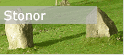
Stonor
Stonor Village is situated about a mile from Henley-on-Thames. It is a small village with a large old manor house.
[see photos]
Town Hall
Town Hall is located in the centre of Henley-on-Thames.
[see photos]
Turville
Turville is a small and stunningly beautiful village a few miles away from Henley-on-Thames.
[see photos]
Valley Road
Valley Road is a large residential road in Henley-on-Thames. Valley Road is made up of former police houses. This is where you will find Valley Road school.
[see photos]
Watermans Road
Watermans Road is a residential road located on the edge of Henley-on-Thames.
[see photos]
West Street
West Street is a quiet one-way road that runs down to the centre of Henley-on-Thames.
[see photos]
Wharfe Lane
Wharfe Lane is a secluded lane that runs alongside the river in Henley-on-Thames.
[see photos]
Wilson Avenue
Wilson Avenue is a residential road in Henley-on-Thames.
[see photos]
Wootton Road
Wootton Road is a small residential road situated on the edge of Henley-on-Thames.
[see photos]
Harpsden
Harpsden is a small village located very close to Henley-on-Thames with a small church and golf course.
[see photos]
Station Road
Station Road is a busy place in Henley-on-Thames located just outside the main town centre area.
[see photos]
Grove Road
Grove Road is a small residential road that branches off Reading Road on the outskirts of Henley-on-Thames.
[see photos]
Sky
Red Kites are an increasingly common sight in the sky above Henley-on-Thames.
[see photos]
Gainsborough Crescent
Gainsborough Crescent is one of a collection of roads on the edge of Henley that bear the Gainsborough name.
[see photos]
Countryside
Situated on the southern edge of the Chiltern Hills, the countryside that surrounds Henley is truly some of the most scenic in England.
[see photos]
Pack and Prime Lane
Pack and Prime Lane is an ancient way that was used as a drive to cut off the river bend around Reading in the days when there were no locks.
[see photos]
Tilebarn Close
Tilebarn Close is a small modern residential area in Henley situated next to The Henley College playing fields.
[see photos]
Upton Close
Upton Close is a circular road situated off Reading Road opposite St Mark's Road in Henley.
[see photos]
Saint Andrews Road
Saint Andrews Road is a long steep road that runs down to join Reading Road in Henley.
[see photos]
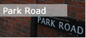
Park Road
Park Road is a residential road in Henley that branches off Reading Road.
[see photos]
Grange Road
Grange Road is a small residential road in Henley.
[see photos]
Marmion Road
Marmion Road is a small residential road in Henley.
[see photos]
Quebec Road
Quebec Road is a private road that branches off Reading Road in Henley.
[see photos]
Walton Avenue
Walton Avenue is a private stone road that branches off Harpsden Road in Henley.
[see photos]
Orchard Close
Orchard Close is a small private residential road in Henley that branches off Saint Andrews Road.
[see photos]
Badgemore
Badgemore is an area on the outskirts of Henley with a golf course.
[see photos]
Greys Hill
Greys Hill is a short narrow road that runs parallel to Greys Road in Henley. It is where you will find Trinity Church.
[see photos]
Goodall Close
Goodall Close is a small residential area in Henley. It's a fairly new addition to the town having been built on the former Southfield site of The Henley College.
[see photos]
Queen Street
Queen Street is a road located in central Henley that joins Friday Street to Station Road.
[see photos]
Putman Place
Putman Place is a small lane located in central Henley that branches off Friday Street.
[see photos]
Wyndale Close
Wyndale Close is a small residential cul-de-sal located off Station Road in Henley.
[see photos]
Vicarage Road
Vicarage Road in Henley runs perpendicular to Saint Andrews Road and Saint Marks Road and is where you will find Trinity School.
[see photos]
Rotherfield Road
Its idyllic character makes Rotherfield Road one of Henley's most sought after roads for premium residential housing.
[see photos]
Damer Gardens
Damer Gardens is a residential close located just off of Vicarage Road in Henley.
[see photos]


